Navigation: Where to park
Jochen Seitz from the Fraunhofer Institute for Integrated Circuits explains research work into seamless indoor and outdoor positioning
Always the same problem, as the parking garage becomes closer the accuracy of GPS localisation decreases and in the garage itself GPS localisation is no longer available. When driving an owned car it is a nuisance, but if participating in car sharing it can be a show stopper. How can an unknown car be found in a large parking garage in a short time?
Navigation systems based on satellite systems such as GPS have found their way into cars and smartphones. But a precise and expensive satellite navigation system is no solution to the problem of enabling seamless indoor and outdoor positioning.
Depending on the quality of systems and additional services, such as for example differential GPS and radio based correction services, the accuracy varies from several tens of metres to several metres under good conditions. Good conditions in terms of GPS are the availability of many satellite signals, a good satellite constellation and no effects such as reflections scattering and signal blocking. These effects are more likely to occur the more densely an area is populated.
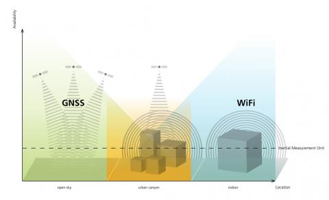
GPS works well in rural areas or on a freeway, but its performance decreases in urban areas, as shown in the diagram. If a car enters an indoor area such as an underground parking garage, satellite signals are no longer available. In other words, the accuracy of a car navigation system drops if a car is approaching a building and is interrupted when entering a building.
A way to increase availability, robustness and accuracy of a positioning systems is to combine different sensors and systems via sensor fusion. There are many different signals and systems that can also be used for determining the position.
In rural areas satellite systems are available together with communications systems such as GSM, UMTS and LTE. In urban areas and indoor environments, communications systems such as wlan and Bluetooth are widely available. Inertial sensors that measure accelerations and angular rates are available anywhere, but stand-alone inertial navigation systems suffer from drift rates over time.
Looking at sensor fusion algorithms and positioning systems, various positioning systems and services are being tested in 1400 square metres of test space equipped with different kinds of reference and positioning systems, especially for indoor positioning.
For pedestrian and car navigation, the focus is on combining GPS, wlan positioning and inertial sensors via sensor fusion. These are available in many mobile phones and embedded platforms. With inertial sensors, additional information on the motion state of the user can be derived and used to predict the trajectory from a known starting position. This process is called dead reckoning. For pedestrians, steps can be detected, and the step lengths can be estimated to get the walked distance. Furthermore, it can be detected if the person carrying a smartphone has entered a car and if the car has started to move.
A seamless positioning system for cars has been realised. It uses wlan positioning within an underground parking garage and GPS outside of the parking garage. If satellites and wlan base stations are receivable, the sensory data of both positioning systems are combined to improve accuracy. It is now possible for a smartphone user to navigate from a meeting room to his or her car in the underground parking using the same application to navigate seamlessly with the car to a destination. This is especially useful in car sharing, where a person has never seen the car before it is booked for the trip.
Work is progressing to improve the algorithms and integrate the developed algorithms into a purely software-based method that can be easily integrated into mobile devices. Location based services are feasible both as local services on the mobile device and as network-based services. This enables continuous positioning even in multi-story buildings or underground facilities.
For seamless positioning, a particle filter has been used to estimate pedestrian and vehicle positions using GPS, wlan signal strength and inertial sensor measurements. It is a recursive filter that spreads particles in position space, as hypotheses for possible user positions, using motion models based on dead reckoning with inertial sensors. These particles are then evaluated with the current GPS and wlan measurements. Each particle gets a weight and can be used to calculate the final position. On a test track in Nuremberg, Germany, the maximum positioning error was three metres within the parking garage and ten metres outside the parking garage.
With an accuracy of a few metres, a parked car can easily be found by a car sharing participant regardless of whether the car is parked indoors or outdoors.
Other fields of application for seamless indoor and outdoor positioning are guidance systems for cities, museums and public transportation, as well as for company buildings, warehouses and production facilities.
Jochen Seitz is group manager for multi-sensor systems at the Fraunhofer Institute for Integrated Circuits